Welcome To KEY TO THE CITY's Page For
Libby
Lincoln County, Montana
ZipCodes
59923
Page Contents for Libby, Montana
History & History-related items
Chamber of Commerce.
Community events.
Organizations, Churches, and Sports.
Statistics & Facts
The Montana state capital is Helena.
The population of Libby is approximately 2,880 (2009), 2628 (2010).
The approximate number of families is 1,264 (2000), 1252 (2010).
The amount of land area in Libby is 3.3 sq. kilometers.
The amount of surface water is 0 sq kilometers.
The distance from Libby to Washington DC is 2139 miles.
The distance to the Montana state capital is 212 miles. (as the crow flies)
Libby is positioned 48.38 degrees north of the equator and 115.55 degrees west of the prime meridian.
Libby elevation is 2,066 feet above sea level.
Libby per capita income is $ 17,681 (2008).
Libby median income is $ 31,708 (2008).
The Libby median home price is $ 116,881 (2008).
Libby average annual precipitation is 18.85 inches peryear.
Libby average annual snowfall is 55.6 inches per year.
Location
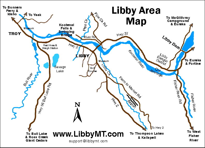
about three hours east of Spokane, Washington and 3.5 hours northwest of Missoula. It is located at the US Highway 2 and State Highway 37 junction and is about 89 miles northwest of Kalispell. Other nearby communities include: Troy, Noxon, Heron and Trout Creek - all in Montana and Moyie Springs, East Hope, Hope, Bonners Ferry, Clark Fork and Kootenai - all just across the border in Idaho
A map of the Libby area
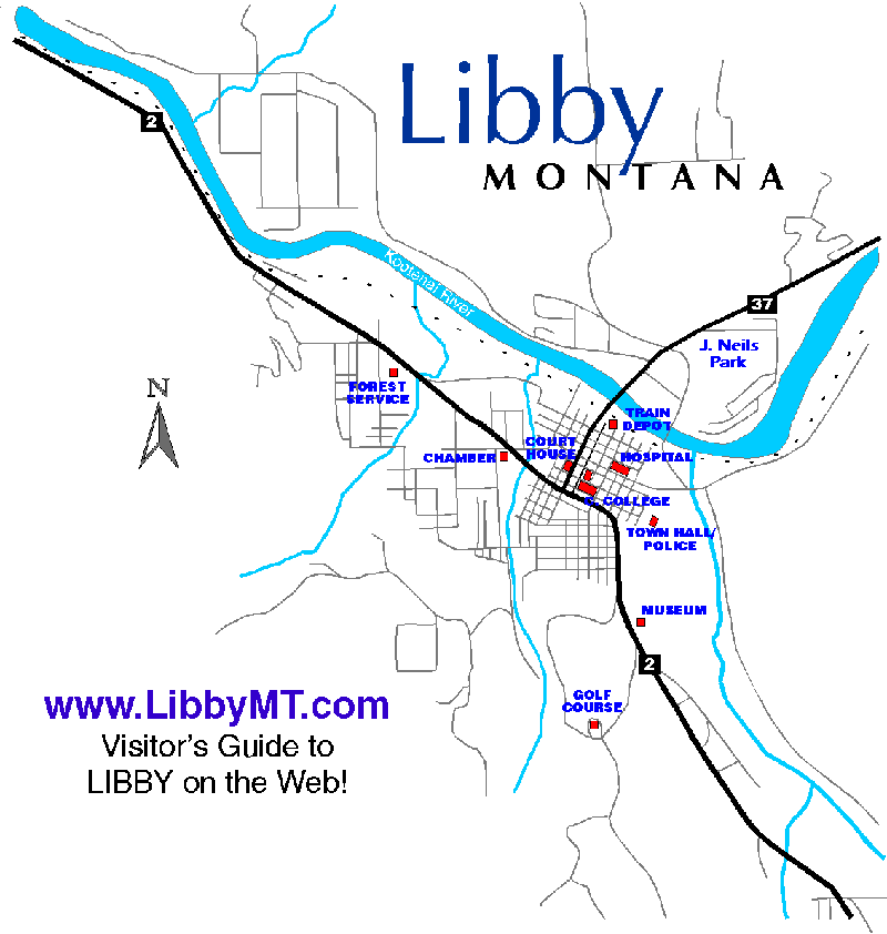
A town map for Libby.
Return to Index
Weather
seasonal with cooler summers and cold winters. Most snow falls between December and February. There are an average of 79 freeze-free days each year. Humidity is low in this area most of the year. The average temperature in the winter is 30.8 degrees F. and in the summer, 89.7 degrees F.
Return to Index
History & History Related Items
Libby was named for the daughter of one of the early settlers.
Members of the Kootenai Native American Tribe were the first inhabitants of the area. They especially liked the soft stone they used for carving they found in the Pipe Creek quarry. Explorers came into the area in the early 1800s. Trappers and traders also arrived around the same time. Forts were built along the Kootenai River, mostly for trading purposes. During the mid-1860s, mining for gold had a brief run. The Snowshoe mine opened in the late 1800s and was the most successful in the area. For much additional information, see the website below. Libby was named the county seat for Lincoln County in 1909.
Here is a history page for Libby and the area.
Return to Index
Attractions
Winters here are cold and beautiful but as the snow melts, the area comes alive with hiking, lakes, fishing, camping and more. The Cabinet Wildernes Area offers unlimited opportunities for the outdoor crowd. The Kootenai River flows 485 miles from Canada through Montana and Idaho and finally back to Canada. Lake Koocanusa is a 90 mile long reservoir behind Libby Dam and offers many recreational activities from boating to camping on the shore. Covering northwest Montana and northeast Idaho, the Kootneai National Forest offers opportunities for all types of outdoor recreation.
Heritage Museum
on Highway 2, south of town.
A 12 sided log building with exhibits and examples of local wildlife. Please see the website for current hours of operation.
34067 US Hwy 2
P.O. Box 628
Libby, MT 59923
Phone: 406-293-7521
Libby Dam
17 miles upstream from Libby on the Kootenai River. The structure is 422 feet tall and 3,055 feet long. Tours are available.
Learn lots about Libby at this informative site.
Memorial Center
A center for culture in the Libby area operated by the Kootenai Heritage Council.
Kootenai Falls
located next to US Highway 2 between Libby and Troy, the main falls drops 30 feet. A swinging bridge is also at the site.
Libby Airport is located about seven miles south of the town. It has a 5,000 foot long, 75 foot wide asphalt runway.
Return to Index
Economy & Industry
logging and mining have long been the mainstays of the local economy. The area, though, is changing to an economy built more around tourism and recreation. Given the beauty and outdoor opportunities, this change is not surprising. Libby Dam is just 17 miles upstream from the community. It was finished in 1975.
Kootenai River Development Council, inc.
111 E. Lincoln Blvd
P.O. Box 621
Libby, MT 59923
Phone: 406-293-8406
Return to Index
Libby City Government
City of Libby952 East Spruce St.
P.O. Box 1428
Libby, MT 59923
Phone: 406-293-2737
Libby Chamber
Libby Chamber of CommerceP.O. Box 704
905 W. 9th
Libby, MT 59923
Phone: 406-293-4167
Libby Community Events
March each yearLibby Irish Fair
An annual event with live entertainment, food, arts and crafts, raffles and more. See the website for details.
June each year
Libby Logger Days
A three day event with something for everyone - a carnival, live music, logging events for all ages, a king and queen contest, a parade, lawn mower races and much, much more. See the website for exact dates each year. This event has been held since 1960!
Wednesdays during June and July
Lemonade on the Lawn
This annual event is held each Wednesday in the summer at the library. Free lemonade is provided and a lunch is available to purchase. There is entertainment each week. This event is used as a fundraiser for the community.
Held in July each year
PRCA Kootenai River Rodeo
This annual event is held at J. Neils Memorial Park in Libby. Many events will be held as well as food for purchase. See the website for details.
Each year in August
Riverfront Blues Festival
This is a two day event held at Riverfront Park Pavillion on the Kootenai River. See the website for exact dates and times and costs for the festival.
Each year in August
Two Rivers Rendezvous
An annual mountain man event sponsored by the Kootenai Muzzleloaders of Libby. Participants must have time-period clothing and equipment. See the website for details.
Each year in August
Ignite the Nites
An annual event held the 3rd weekend of August since 1961. Sponsored by the Igniters Car Club.
This event is held in downtown Libby and features a car show, burn-out contest and cruise. Don't miss it! See the website for more information.
Held in September each year
Libby Nordicfest
Various events such as: a parade, horse show, dinners, fine arts shows, craft and quilt show and more are part of this annual event. See the website for more information.
Libby Organizations
Libby Chamber of CommerceP.O. Box 704
905 W. 9th
Libby, MT 59923
Phone: 406-293-4167
Libby Libraries
Lincoln County Public Library - Libby220 W. 6th Street
Phone: 406-293-2778
Libby Schools
Libby School DistrictHome of the Libby Loggers
724 Louisiana Ave
Libby, MT 59923
Phone: 406-293-8811
HIGHER EDUCATION
Flathead Valley Community College
Lincoln County Campus
225 Commerce Way
Libby, Montana 59923
Phone: (406) 293-2721 Libby
Miscellany
The population of Libby was:1890 - 260
1900 - 296
1910 - 630
1920 - 1,522
1930 - 1,752
1940 - 1,837
1950 - 2,401
1960 - 2,828
1970 - 3,286
1980 - 2,748
1990 - 2,532
1998 - 2,675
2000 - 2,626
2007 - 2,886
The number of housing units was:
2000 - 1,264
Median age:
2000 - 43 years
population density:
2000 - 2,061.9 persons per square mile
2008 - 2,261 persons per square mile
Median household income:
2000 - $ 24,276
2008 - $ 31,708
Per capita income:
2000 - $ 13,090
2008 - $ 17,681
Libby is located in the Mountain Time Zone and does participate in daylight savings time during a portion of the year.
Contribute information for this community or any other community on the Key To TheCity website
Be sure to include the name of the community and its state when contacting Key to the City as you are NOT directly contacting this community.
Thanks for visiting Key to the City. Come back again! Soon!
- The information on Key to the City is from multiple sources including government, commerce, libraries, individuals and organizations. There is no guarantee of the accuracy or timeliness of the information presented on these pages, therefore, please use at your own risk.
